



Introduction
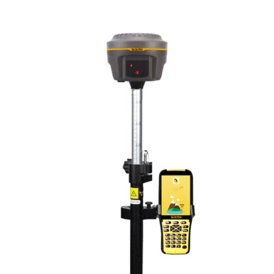
Modern surveying, construction, agriculture, and geospatial industries rely heavily on accurate positioning systems. Among the most advanced technologies available today are GNSS rtk receiver Solutions for High-Precision Positioning, which provide centimeter-level accuracy in real time. These systems have transformed how professionals capture spatial data, enabling faster workflows and more reliable results.
In this article, we will explore how GNSS RTK Receiver Solutions for High-Precision Positioning work, their key benefits, and where they are most effectively used.
What Are GNSS RTK Receiver Solutions?
GNSS (Global Navigation Satellite System) refers to satellite navigation systems such as GPS, Galileo, GLONASS, and BeiDou. RTK (Real-Time Kinematic) is a correction technique that enhances GNSS accuracy by using a fixed base station and a rover receiver.
Together, GNSS RTK Receiver Solutions for High-Precision Positioning deliver real-time corrections that reduce errors caused by atmospheric conditions, signal delays, and satellite geometry.
These systems typically include:
- A base station that stays at a known coordinate
- A rover receiver that collects field data
- A communication link for real-time corrections
How GNSS RTK Technology Works
The core principle behind RTK is differential correction. The base station calculates its position error by comparing known coordinates with satellite data. It then sends correction signals to the rover.
This process allows GNSS RTK Receiver Solutions for High-Precision Positioning to achieve accuracy levels down to the centimeter range.
Key Steps in RTK Processing:
- Satellites transmit positioning signals
- Base station receives and calculates error
- Correction data is sent to rover in real time
- Rover applies corrections for precise positioning
Benefits of GNSS RTK Receiver Solutions
1. Centimeter-Level Accuracy
One of the biggest advantages of GNSS RTK Receiver Solutions for High-Precision Positioning is their exceptional accuracy, making them ideal for surveying and engineering applications.
2. Real-Time Data Collection
Users can view corrected positions instantly, eliminating the need for post-processing and saving valuable time in the field.
3. Increased Productivity
By reducing manual measurements and setup time, these systems significantly improve operational efficiency.
4. Versatility Across Industries
From construction to agriculture, GNSS RTK Receiver Solutions for High-Precision Positioning support a wide range of professional applications.
Applications of GNSS RTK Technology
Land Surveying and Mapping
Surveyors rely on RTK systems for boundary mapping, topographic surveys, and infrastructure planning. The precision offered ensures reliable and legally defensible data.
Construction and Engineering
In construction, RTK receivers help with site layout, machine control, and alignment tasks. This reduces costly errors and rework.
Precision Agriculture
Farmers use RTK guidance systems for planting, spraying, and harvesting with high accuracy, optimizing crop yield and reducing waste.
Drone Mapping
UAVs equipped with RTK modules produce highly accurate aerial maps without requiring extensive ground control points.
Challenges and Limitations
While powerful, GNSS RTK Receiver Solutions for High-Precision Positioning also have limitations:
- Dependence on stable communication links
- Reduced performance in urban canyons or dense forests
- Higher initial equipment cost compared to standard GPS
Despite these challenges, advancements in satellite networks and correction services continue to improve reliability and accessibility.
Future of High-Precision Positioning
The future of positioning technology is moving toward hybrid systems that combine GNSS RTK with other technologies such as inertial measurement units (IMUs), AI-based corrections, and cloud connectivity.
As these innovations evolve, GNSS RTK Receiver Solutions for High-Precision Positioning will become even more accurate, accessible, and integrated into autonomous systems like self-driving vehicles and robotic survey platforms.
Conclusion
In today’s data-driven world, precision is essential. GNSS RTK Receiver Solutions for High-Precision Positioning provide unmatched accuracy and efficiency for professionals working in surveying, agriculture, construction, and geospatial analysis.
